Alaska is assuredly an American state, yet it is more than 2,000 miles from Washington, a state that is pretty close. Many peoples raise the question of whether you can drive to Alaska, which includes whether you can go there on ocean currents or by the windy road linking through Canada.
Both choices involve some preparation but provide unmatched landscapes and an exciting experience. The answers to all questions are simple and clear, which are mentioned here with all pros and cons.
Alaska is accessible by car from every state. The Alaska Highway must be taken from Dawson Creek in British Columbia to most of the USA, except California, Oregon, and Washington State, where the Dease Lake Highway is preferable to Yukon.
So here we will tell you about different routes with their advantages and disadvantages.
Do You Want To Travel To Alaska From The United States Through Canada?
During World War II, the Alaska Highway was built through Canada to connect Alaska to the mainland United States. It starts at the intersection of three Canadian roads at Dawson Creek, British Columbia, and travels via Whitehorse, Yukon, to Delta Junction, Alaska.
This Highway was built in 1942, and it is 2232 km long. Alaska Highway’s 80th anniversary was in 2022.
The Richardson Highway and Alaska Highway merge at Delta Junction, where they continue to Fairbanks and other interior sites. This route is now regarded as a road through a wilderness rather than a wilderness road. Most of the highway’s surface is asphalt, and upgrades are always being made.
Highway Intersections
Many highways intersections start from Dawson creek, Taylor, Fort St. John, Charlie Lake, and Fort Nelson in British Columbia through British Columbia – Yukon border and then Teslin, Johnsons Crossing, Jake’s Corner, Carcross Cutoff, Whitehorse, Haines Junction, Beaver Creek and then through Canada–United States border till Tetlin junction, Tok and Delta junction in Alaska.
Route Conditions
The first 300 miles of the roadway between Dawson Creek and Fort Nelson are mostly straight. The Alaska Highway crosses the Rocky Mountains to the north of Fort Nelson.
Expect 200 miles of about 10 percent graded, curvy, and small hilly roads with few passing lanes.
The Alaska Highway bends and rolls through the wilderness on a two-lane, paved road. Even though the majority of the road is asphalt-covered, drivers may come across rough sections with chuckholes, loose gravel, and sudden bumps known as frost heaves.
These are brought on by the ground’s periodic freezing and thawing, which ripples the pavement. Road condition reports are available online.
Roadway Inspections
The road inspection team does the maintenance and conversion program for the road surface, including 25 bridges, 32 large culverts, 2130 small culverts, 10 yards, 10 salt sheds, numerous pits, and quarries.
Services Offered
Along the Alaska Highway, gas stations, restaurants, and hotels are often 20 to 50 miles apart. The distance with the fewest services is around 100 miles. Most services and not all companies are open all year round. There are both public and private campsites along the Alaska Highway.
Mobile Phone Coverage
- There is an irregular service from km 132 to 556 and some areas with no services.
- Near Yukon Border, there is no cell phone service at 557 km.
Driving Caution
Always use defensive driving. Drive slowly, keep your headlights on, and keep an eye out for frost heaves.
Workshops For Cars
Before beginning, check the condition of your car and its tires. Consider installing transparent plastic headlamp covers or a wire-mesh screen over the front to shield your car from flying pebbles.
Although the North has well-stocked vehicle stores, you should bring tools for emergency repairs and at least one spare tire. Extra warm clothes are a need in the winter.
Landscapes
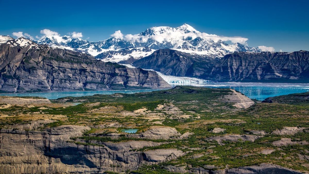
This Highway passes through different rivers, including Spirit River, Peace River, Liard River, Ross River, and several lakes, including Cecil Lake, Dease Lake, and Teslin Lake, which provide a whole aesthetic view of this Highway. There are also some other points of attractions for tourists which make them feel relaxed.
Conclusion
This Highway is for those who love to go on long drives and always get ready for an adventure. As it is famously said, difficult paths always lead to something beautiful, such as Alaska Highway.
This Highway is recommended for young people who can drive on every kind of road as this road passes through thick forests. Only 5% of tourists arrive in Alaska through the Alaska-Canada Highway, but those who do are in for a unique week-long experience through some of the most stunning terrains on earth.
Do You Know The Highway Which Connects Alaska to British Columbia?
In the Canadian province of British Columbia, the Highway, also referred to as the Dease Lake Highway, the Stikine Highway, and the Terrace-Kitimat Highway, extend furthest to the northwest.
The highway, which travels from the remote regions of the province, 1975 was initially given the name British Columbia Highway 37. Then, in 1986, the Highway was expanded in the south to Kitimat, replacing what was then known as Highway 25. The road temporarily enters the Yukon at its northernmost point.
Visitors from the Yukon or Alaska have a great alternative route due to the 724 km/450-mile-long Cassiar Highway 37. It was built in 1975 and upheld by the British Columbia Ministry of Transportation and Infrastructure.
Highway Intersections
There are several intersections from Kitimat, Terrace, Kitwanga, Cranberry Junction, Meziadin Junction, Bell II, and Dease Lake in British Columbia through the British Columbia – Yukon border till Whitehorse and Watson Lake in Yukon.
Route Conditions
There are loose gravel patches with no guardrails, lane markers, or reflectors. There are around three one-lane bridges that you’ll come over. It often has fewer lanes than other two-lane highways and minimal to no shoulders.
Services Offered
Along the Stewart-Cassiar Highway, it might be difficult to locate a warm bed and a good supper. The Bell II Lodge and Dease Lake are the greatest spots to stay the night. The former offers accommodations for a little over $200, while the latter offers a few choices for around $80.
The provincial parks at Kinasakan Lake, Meziadin Lake, and Boya Lake are your best option if you’re searching for something less expensive and have all the equipment you need to be self-sufficient.
Mobile Phone Coverage
There is zero cell phone coverage during the entire journey on Stewart-Cassiar Highway.
Fuel Stations
You should be careful with gasoline use because this is a distant country. Meziadan Junction (169 km), Bell II Lodge (249 km), Iskut (405 km), Dease Lake (480 km), and the Yukon border are places where you may stop for fuel (727 km).
At Dease Lake, the only mechanic on this route, should something malfunction. The only part of the journey from Dease Lake to the Yukon Border that requires carrying additional gasoline is the last leg, although you should exercise caution the entire way and have a reserve jerry can.
Landscapes
The Cassiar Highway cuts through a region of mountains, rivers, lakes, and glaciers. Several communities are on the way. To visit the nearby communities of Stewart, visitors should spare some time.
Despite the area’s longstanding reputation for glaciers and waterfalls, one of the main draws is still the welcoming people and mountain views in the North. On your journey up north, this region of British Columbia and Alaska is one of the most stunning.
Despite the area’s longstanding reputation for glaciers and waterfalls, one of the main draws is still the welcoming people.
Conditional Parks and Camping
Along Highway 37 are three provincial parks. They offer hiking, fishing, and sightseeing opportunities throughout the summer and are available for camping.
- Boya Lake Provincial Park – 150 km north of Dease Lake
- Kinaskan Lake Provincial Park – 364 km north of Kitwanga
- Meziadin Lake Provincial Park, -150 km north of Kitwanga
Conclusion
The people who want to go to Alaska alone can choose this track because it is good for those who love long traveling, and it is not as such family-friendly.
Are You The One Who Loves Biking?
Then Stewart–Cassiar Highway is best for you because it fulfills your biking wish and leads you to Alaska. Once the visitors finish this route, they must travel on the logging roads south of Meziadin Junction, which was renovated in 1970.
Seward: The City of Alaska
The Seward Highway runs 125 miles (201 km) from Seward to Anchorage in the U.S. state of Alaska. It passed through the picturesque Kenai Peninsula, Chugach National Forest, Turnagain Arm, and Kenai Mountains and was finished in 1951.
Alaska Route 9 (AK-9) denotes the first 37 miles (60 km) of the Seward Highway from Seward to the Sterling Highway, while AK-1 denotes the remainder of the route to Anchorage.
AK-1 goes west towards Sterling and Homer at the intersection with the Sterling Highway. The Seward Highway leads into Anchorage and is constructed to motorway standards for around eight miles (13 km).
Highway Intersections
There are several intersections from Seward, Bear Creek, Primrose, and Moose Pass in Kenai Peninsula to the Municipality of Anchorage.
Route Conditions
It pays to go slowly because the meandering layout offers breathtaking panoramic vistas and is entertaining for a leisurely ride.
The journey takes around five hours, although many spread it out over many days to explore the region thoroughly. There are fishing communities, mining communities, and national forests.
According to the number of car accidents, it is considered one of Alaska’s most hazardous highways. The stretch between Anchorage and the Portage Glacier Exit is the most hazardous.
Although this route is typically available all year long, it may close at any moment if the access is not snow-cleared.
Services
All services are available on this Highway, including auto shops, fuel stations, and food restaurants.
It is advised that you fill up your tank of petrol before beginning your excursion. The lone petrol station between Anchorage and Seward is at Girdwood at the junction of Seward Highway and Alyeska Highway.
Before starting the trek, it is also advised to get some refreshments at a grocery shop in Anchorage. You’ll have to wait till Girdwood or Whittier if you don’t want to wait. It’s a good idea to visit the REI in Anchorage and get bear spray if you intend to hike while in Alaska.
Landscapes
This Highway is well-known for its spell-bounding views.
- Beluga Point is well-known for whale watching.
- Driving between Beluga point and Bird point is the best spot to watch Dall sheep.
- Bird Point is famous for its eye-catching view of Turnagain Arm
- Girdwood is a small town from where you can see Glacier Creek.
- Virgin Creek Waterfalls is the best tourist attraction.
Conclusion
This is the best highway you can drive to or within Alaska. Several recreation points enhance the overall traveling experience. Just check the weather before traveling on it.
Alaska Marine Highway
Since 1963, the Alaska Marine Highway System has provided year-round passenger and car service to 33 Alaskan settlements, Bellingham, Washington, and Prince Rupert, British Columbia. The AMHS fleet now consists of eleven ships, and more ferries are scheduled to be added. All-year-round sailings.
The Alaska Marine Highway System is a unique instance of a shipping company in the United States that provides regularly scheduled service with passenger transit as its primary objective rather than pleasure or entertainment.
Longer voyages are common, although in contrast to a conventional cruise line’s luxury, most meals are served in a cafeteria, and accommodations are an additional expense.
Ports
Bellingham, Prince Rupert, Ketchikan, Wrangell, Petersburg, Kake, Sitka, Pelican, Angoon, Tenakee, Hoonah, Juneau, Haines, Skagway, Gustavus
Traffic Flow
The AMHS transports 100,000 cars and about 350,000 passengers annually. The Alaska Marine Highway reported transporting 340,412 people and 109,839 cars in their 2008 Annual Traffic Volume Report; this is the most passenger ridership in eight years and the largest vehicle ridership in sixteen.
Summer visitors love taking the ferry (one of the primary reasons Bellingham and Prince Rupert are AMHS destinations).
On the rear of mainline ships, tent communities frequently appear. For travelers on a tight budget, the AMHS is one of the best ways to reach the “Last Frontier.” In the winter, service is considerably reduced.
Due to the decrease in passenger and vehicle traffic, vessels typically undertake overhauls and modifications during this time (attributed to a lack of tourists).
| Main Routes: | Daytime Boat Routes: | Shuttle Routes: |
| Bellingham → Ketchika→ Wrangell → Petersburg → Juneau ↪ Haines → Skagway → Sitka | Juneau → Angoon Juneau → Gustavus → Hoonah | Ketchikan → Metlakatla |
| Prince Rupert → Ketchikan → Wrangell → Petersburg → Kake ↪ Sitka → Juneau → Haines → Skagway | Juneau → HainesJuneau → Skagway |
Can You Drive to Alaska By Ferry?
Some travelers utilize the ships because they enjoy traveling by sea – the ports, the landscape, but don’t want to experience a flashy, floating resort. These boats are simple, yet they are also clean and cozy. You can pay attention to what’s outside the boat rather than within it.
The routes blend well-known ports with less well-known ports in Alaska. You may travel with locals in Alaska and visit places off the beaten path.
It’s a fantastic method to connect distant parts of an Alaskan trip. The ferries allow travelers in cars, RVs, and backpacks to travel across parts of Alaska that would take too long to cover on foot.
Other Amenities
- Pets are allowed.
- The 11 ferry boats in the fleet may accommodate up to 600 passengers or just 100.
- The reservation specialists at the AMHS can offer advice if you need it, whether you want to plan a stand-alone cruise holiday or something that is a component of a long journey.
Things You Can Do On Ferry
If your boat trip lasts many days, you can reserve bed-style accommodations that accommodate many peoples.
Many tourists spend the night beneath the stars, while others camp in a deck chair in the solarium.
Observation decks, arcades, reading rooms, and children’s play areas are common attractions on ferries.
Final Words
Here is a detailed description of how to reach Alaska in different ways. It depends on the visitor’s budget; for example, some people can come by airplane, or some have a low budget, so they travel on the road, and some might travel by ferry who are adventurous.
So, all the traveling ways have different charms and facilities. You can easily choose the way by which you have to reach Alaska.